

Introduction
India’s quest for water security has led to one of the most ambitious engineering initiatives in its modern history: the National River Linking Project. At the absolute forefront of this grand vision is the Ken Betwa River Linking Project, a multi-billion-dollar infrastructure plan designed to solve the chronic water scarcity of the Bundelkhand region.
However, as concrete mixers gear up, so do environmental legal battles and grassroots resistance. The ongoing Ken Betwa Protest represents a classic, high-stakes collision between developmental necessity and ecological conservation. For students, competitive exam aspirants (especially UPSC), and environmental enthusiasts, decoding this debate requires unpacking complex hydrological data, statutory wildlife protections, and the deep socio-economic realities of rural India.
1. The Ken River (The Karnavati)
Historically known as the Karnavati, the Ken River is famous for its clean waters, rare stones, and the deep geological formations it carves across the landscape.
Origin and Detailed Course
- The Source: The Ken River originates on the northwestern slopes of the Kaimur Hills/Range near the village of Ahirgawan. This is located in the Katni district of Madhya Pradesh (historically associated with the broader Jabalpur area), sitting at an elevation of about 550 meters above sea level.
- The Journey: From Katni, it flows northwards through the Madhya Pradesh districts of Panna and Chhatarpur, cutting a magnificent, 60-kilometer-long, 150–180 meter deep canyon through the Bijawar-Panna hills. This stretch creates spectacular waterfalls, such as Raneh Falls (often called the “Mini Canyon of India”) and Pandav Falls. It flows directly through the heart of the Panna Tiger Reserve.
- Confluence (The Mouth): The river eventually crosses into Uttar Pradesh (traveling through Mahoba, Banda, and Hamirpur districts) before it merges with the Yamuna River at Chilla village near Fatehpur in Uttar Pradesh.
- Total Length: Approximately 427 to 430 kilometers.
- Major Tributaries: Sonar, Bearma, Kopra, Urmil, Mirhasan, and Khudar.
- Unique Fact: The Ken riverbed is famous for producing Shajar (Dendritic Agate), a rare, translucent stone showing nature-made, tree-like fossil patterns inside it.
The Betwa River (The Vetravati)
Mentioned frequently in ancient Indian literature and the epic Mahabharata as the Vetravati, the Betwa is a longer, economically heavy river that flows over the vast Malwa Plateau.
Origin and Detailed Course
- The Source: The Betwa River originates in the Vindhya Mountain Range near Kumra village (also cited near Jhiri/Obedullaganj) in the Raisen district of Madhya Pradesh. It begins just north of the Narmadapuram (Hoshangabad) district at an elevation of roughly 576 meters above sea level.
- The Journey: The river flows in a northeasterly direction across the Malwa Plateau. It touches prominent historical and cultural towns in Madhya Pradesh like Sanchi (famous for the Buddhist Stupa), Vidisha, and the heritage town of Orchha.
- Confluence (The Mouth): It exits Madhya Pradesh and flows through the Bundelkhand plains of Uttar Pradesh (districts like Lalitpur, Jhansi, Jalaun, and Hamirpur). It meets its end by emptying into the Yamuna River in the Hamirpur district of Uttar Pradesh.
- Total Length: Approximately 590 kilometers (with 232 km tracking through Madhya Pradesh and 358 km flowing through Uttar Pradesh).
- Major Tributaries:
- Left Bank: Halali, Kaliyasoth, Urwashi.
- Right Bank: Bina, Dhasan, Jamni.
- Unique Fact: The Betwa is heavily dammed to support regional farming, housing major reservoirs like the Rajghat Dam, Matatila Dam, and the Paricha Dam.
What is the Ken-Betwa River Linking Project?
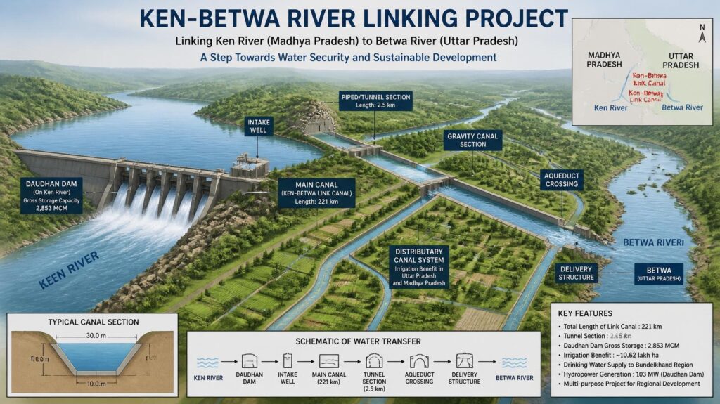
The Ken Betwa River Linking Project (KBLP) is the maiden initiative under India’s National Perspective Plan (NPP) for the interlinking of rivers. The core concept centers on a “surplus-to-deficit” hydrological transfer. Under this framework, excess water from the Ken River basin in Madhya Pradesh will be redirected via an extensive canal system to the water-starved Betwa River basin in Uttar Pradesh.
Both the Ken and the Betwa are critical perennial/semi-perennial rivers that originate in the highlands of Madhya Pradesh and flow northwards to join the Yamuna River as major tributaries.
Objectives of the Project
The core blueprint of the KBLP is engineered to fulfill three principal regional objectives:
- Irrigation Expansion: To supply sustainable, year-round canal irrigation to over 10.62 lakh hectares of parched agricultural land in central India.
- Drinking Water Security: To provide clean, piped potable water to approximately 62 lakh people living in drought-prone rural and urban settlements.
- Clean Energy Generation: To harness the flow of transferred water to produce 103 Megawatts (MW) of hydroelectric power alongside an auxiliary 27 MW of solar power installations
History and Timeline
The idea of linking Indian rivers is not new; its roots stretch back to the British colonial era under engineer Sir Arthur Cotton, and later revived by K.L. Rao in the 1970s. The modern iteration of KBLP gained momentum under the late Prime Minister Atal Bihari Vajpayee’s administration.
The timeline below tracks its complex evolution from an engineering concept to its recent groundbreaking foundation:
- National Perspective Plan Launched
1980
The Ministry of Water Resources formulates the NPP, identifying the Ken-Betwa link under the Peninsular Rivers Development component.
- Detailed Project Report (DPR) Phase I
2010
The National Water Development Agency (NWDA) completes the comprehensive feasibility and structural DPR for Phase I.
- Tripartite Memorandum of Agreement (MoA)
March 2021
A historic pact is signed by the Union Minister of Jal Shakti and the Chief Ministers of Madhya Pradesh and Uttar Pradesh to launch the project.
- Union Cabinet Funding Approval
December 2021
The Union Cabinet officially approves the comprehensive funding structure, committing a massive central support layout.
- Foundation Stone Laid
December 2024
Prime Minister Narendra Modi formally lays the foundation stone for the Ken-Betwa River Linking Project at Khajuraho, Madhya Pradesh, initiating field operations.
- Grassroots ‘Water Satyagraha’ Protests
July 2026
Project Components
To execute this massive geographical realignment of water, the project is structurally split into two sequential phases:
Phase I: The Daudhan Dam Complex
The centerpiece of the entire project is the Daudhan Dam, a massive structure planned on the Ken River located right within the boundaries of the Panna Tiger Reserve in Madhya Pradesh. The dam is designed to stand 77 meters high and span 2.13 kilometers in length. It will create a vast reservoir with a gross water storage capacity of 2,853 million cubic meters.
From this reservoir, a 221-kilometer-long Ken-Betwa Link Canal (including two complex water-conveyance tunnels) will cut across the landscape to discharge the surplus water into the Betwa river basin.
Phase II: Downstream Infrastructure
Phase II focuses on utilizing the managed water within the broader grid. It includes the construction of the Lower Orr Dam (on the Orr River), the Bina Complex Multipurpose Project, and the Kotha Barrage. These sub-components extend the distribution network deep into secondary districts.
Which States Benefit?
The KBLP is a interstate initiative directly serving the twin states of Madhya Pradesh (MP) and Uttar Pradesh (UP), specifically focusing on the historically marginalized and drought-ridden Bundelkhand region
| Beneficiary State | Primary Districts Covered | Agricultural Area Targeted |
| Madhya Pradesh | Chhatarpur, Panna, Tikamgarh, Sagar, Damoh, Datia, Vidisha, Shivpuri, Raisen | ~8.11 Lakh Hectares |
| Uttar Pradesh | Banda, Mahoba, Jhansi, Lalitpur | ~2.51 Lakh Hectares |
Budget and Funding
Given its scale, the economic layout of the project is immense:
- Total Assessed Cost: ₹44,605 crore (calculated at base price levels).
- Central Government Support: The Union Government provides a staggering ₹39,317 crore in financial backing, representing roughly 88% of the total budget. This is split into a direct central grant of ₹36,290 crore and a operational loan of ₹3,027 crore.
- Execution Body: A dedicated Special Purpose Vehicle (SPV) named the Ken-Betwa Link Project Authority (KBLPA) has been incorporated to spearhead the day-to-day execution, contracting, and inter-state coordination.
Why is the Project Important?
From a planning perspective, the KBLP is viewed as a vital lifeline for a region on the brink of ecological and economic collapse.
- Mitigating Chronic Bundelkhand Droughts: Bundelkhand suffers from regular, severe meteorological and agricultural droughts. The project aims to break this cycle by replacing erratic rainwater reliance with stable canal infrastructure.
- Halting Distress Migration: Due to repeated crop failures, thousands of small farmers and seasonal laborers migrate out of these districts annually to live in urban slums. Stabilizing agriculture will create reliable local livelihoods.
- Restoring the Groundwater Table: Over-extraction of underground aquifers for farming has caused local water tables to plunge dangerously. Surface water irrigation via canals allows groundwater reserves a chance to naturally recharge.
Why are People Protesting?
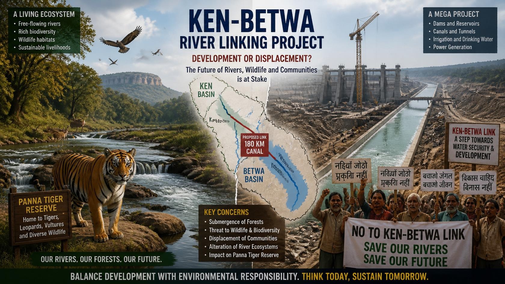
Despite these clear developmental goals, the Ken Betwa Protest has intensified across regional communities and legal courts. The core friction stems from the fact that the project’s primary water-gathering mechanism requires altering a highly sensitive ecosystem and displacing established human settlements. Critics argue that the heavy human and ecological costs are being minimized in favor of engineering targets.
Environmental Concerns
The ecological opposition to the Ken Betwa Link Project is backed by detailed conservation data and field studies.
Panna Tiger Reserve Impact
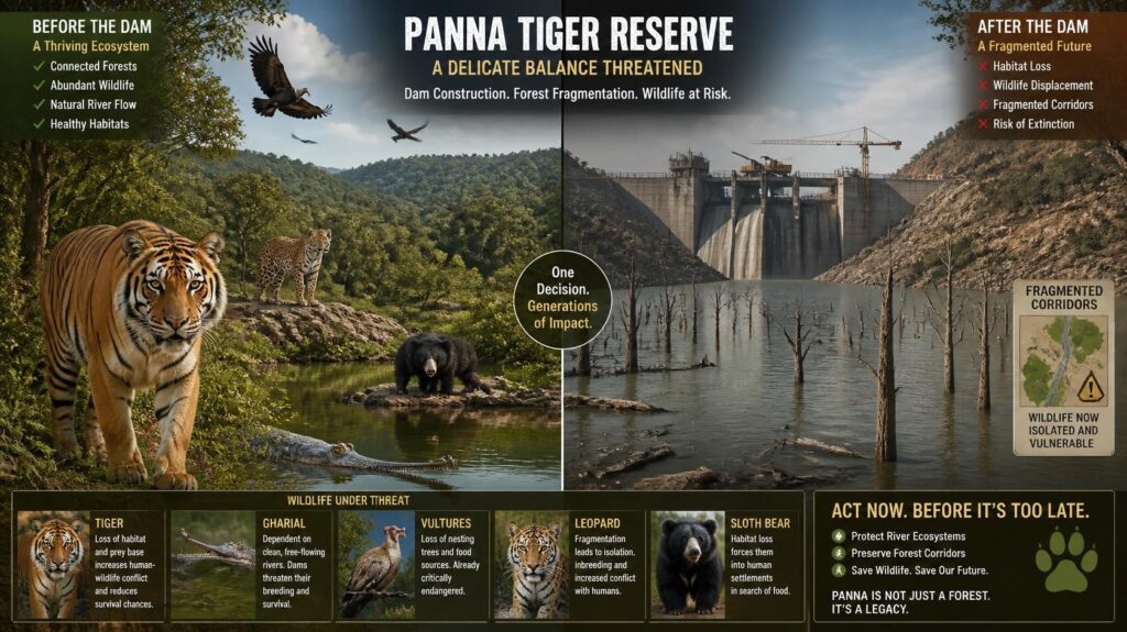
The single biggest point of environmental contention is the direct impact on the Panna Tiger Reserve (PTR) in Madhya Pradesh. The reservoir created by the Daudhan Dam will submerge an estimated 6,017 hectares of pristine forest land inside the core and buffer zones of this crucial wildlife sanctuary.
Forest Loss and Tree Felling
Independent environmental impact assessments show that the impoundment area will lead to the clearing of approximately 23 lakh (2.3 million) mature trees. This represents a significant loss of carbon-sequestering canopy cover that cannot be easily replaced by new plantation programs elsewhere.
Wildlife Habitat Fragmentation
Panna is celebrated for its successful tiger relocation programs. Submerging its river valley will split key wildlife corridors, fragmenting breeding territories not just for tigers, but also for leopards, sloth bears, and striped hyenas.
River Ecosystem Changes
Dams alter a river’s natural hydrology. Downstream sections of the Ken River will see significantly lower seasonal flows, threatening the Ken Gharial Sanctuary. This sanctuary protects the critically endangered Gangetic Gharial (Gavialis gangeticus) and the unique Mahseer fish, both of which rely on rapid, natural river currents to breed.
Biodiversity and Avian Collapse
The gorge area slated for submergence serves as a primary nesting ground for several endangered, cliff-dwelling vulture species. Flooding these deep rock faces will submerge their natural nesting niches, dealing a severe blow to regional avian biodiversity.
Social Concerns
Beyond the wildlife impact, the project directly disrupts local communities.
- Displacement of Villages: The reservoir will completely submerge around 10 rural villages, forcing the involuntary relocation of thousands of families.
- Tribal Communities Impact: A large portion of the displaced population belongs to vulnerable tribal communities, such as the Gond and Korku peoples. These families are deeply tied to the local forests for their cultural identity and daily survival.
- Livelihood Issues: Protesters point out that historical rehabilitation packages in India often fail to deliver on promises. Displaced farmers are frequently relocated away from their traditional rivers, receiving inferior agricultural land that undermines their long-term livelihood security.
Government’s Perspective vs. Environmentalists’ Perspective
The Ken Betwa Link Project serves as a prime case study in environmental governance, highlighting two fundamentally different approaches to resource management.
Arguments Supporting the Project
- Ensuring Regional Water Security: Proponents argue that bringing surface irrigation to over 10 lakh hectares is the only permanent way to drought-proof Bundelkhand.
- Boosting Agricultural Prosperity: Reliable access to water allows smallholders to shift from low-yield millet farming to double-cropping, significantly raising rural incomes.
- Comprehensive Landscape Management Plan (LMP): The government has commissioned the Wildlife Institute of India (WII) to implement an extensive mitigation program. This involves integrating adjoining wildlife sanctuaries (like Nauradehi and Durgavati) into the Panna network to compensate for the lost tiger habitat.
Arguments Against the Project
- Flawed Hydrological Assumptions: Independent experts question the basic premise that the Ken River actually has “surplus” water. As a non-perennial river, its flow drops off significantly during dry summer months, meaning it may not have enough water to spare for the Betwa basin.
- Violations of Wildlife Protection Laws: Environmentalists have argued in court that building a commercial dam inside a national park violates Section 35(6) of the Wildlife (Protection) Act, 1972, which strictly prohibits destroying or diverting wildlife habitats unless it directly benefits the management of wildlife itself.
- Sustainable Alternatives Exist: Critics suggest that the region could achieve water security much faster and at a fraction of the cost through decentralized rainwater harvesting, desilting traditional tanks, and promoting water-efficient crops like oilseeds instead of water-intensive varieties.
Current Status
As of mid-2026, the Ken-Betwa River Linking Project sits at a critical operational turning point. Following the high-profile foundation ceremony in late 2024, the Ken-Betwa Link Project Authority (KBLPA) began early pre-construction planning, site leveling, and marking boundaries for the Daudhan Dam zone.
However, full-scale excavation faces ongoing friction:
- Legal Challenges: The project’s final wildlife clearance remains under intense scrutiny before the Supreme Court of India and the National Green Tribunal (NGT) due to challenges regarding its impact on Panna’s core tiger habitat.
- Ground Protests: In July 2026, local tribal communities in Chhatarpur launched a symbolic “Water Satyagraha”. Protesters stood in local water bodies to demand fair land compensation, transparent public hearings, and concrete guarantees for community rehabilitation before any physical relocation begins.
Frequently Asked Questions (FAQs)
1. What is the main objective of the Ken-Betwa River Linking Project?
The primary goal is to transfer surplus water from the Ken River basin to the water-deficit Betwa basin to provide steady irrigation, drinking water, and hydropower to the drought-prone Bundelkhand region.
2. Why are environmentalists protesting against the Ken Betwa project?
The chief environmental concern is that the Daudhan Dam will submerge over 6,000 hectares of the Panna Tiger Reserve, leading to the felling of 23 lakh trees and fragmenting critical tiger and vulture habitats.
3. Which districts will benefit from this project?
Key beneficiary districts include Chhatarpur, Panna, and Tikamgarh in Madhya Pradesh, along with Banda, Mahoba, and Jhansi in Uttar Pradesh.
4. What is the role of the Daudhan Dam in KBLP?
The Daudhan Dam is the central engineering component of Phase I. Built on the Ken River, it will store water and divert it into a 221-km link canal running to the Betwa River.
5. Is the Ken-Betwa link part of a larger plan?
Yes, it is the historic first project under India’s National River Linking Project (NRLP), which aims to link dozens of peninsular and Himalayan rivers across the country.
6. What animal species are threatened by this project?
Key affected species include the Royal Bengal Tiger, the critically endangered Gangetic Gharial, endangered cliff-nesting vultures, and the native Mahseer fish.
7. How much does the project cost and who is funding it?
The project is budgeted at ₹44,605 crore, with the Central Government providing roughly 88% of the total funds as a mix of direct grants and loans.
8. What alternative solutions do critics propose instead of river linking?
Critics advocate for decentralized water management, including traditional rainwater harvesting, restoring historical tanks, checking small check-dams, and shifts toward climate-resilient farming techniques.
Conclusion
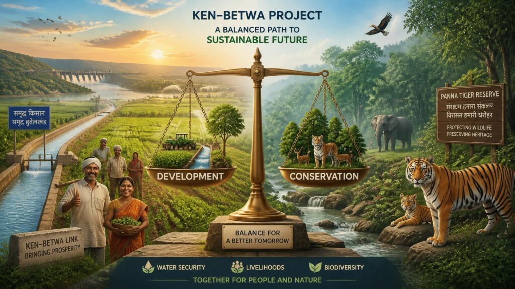
The Ken-Betwa River Linking Project stands as a defining test case for India’s future development path. Providing reliable water to millions in Bundelkhand is an undeniable socio-economic priority. Yet, doing so by altering a premium wildlife ecosystem like the Panna Tiger Reserve carries irreversible ecological risks.
True sustainability lies in finding a balanced path. The future success of the KBLP will depend on the government’s ability to genuinely address the concerns of local communities, implement transparent rehabilitation, and execute scientifically rigorous ecological mitigation plans.